In this Article

ULPB-BIOMECH has developed the M3DAS Data Collection Mobile App used in conducting surveys to determine the mechanization resources that can be visually represented through various types of maps for planning, monitoring, and ascertaining the mechanization situations in specific localities. A database, securely connected to the M3DAS server, stores the data gathered from surveys. It contains processed data which include, but not limited to, geo-tagged machines, available horsepower, machines for custom hiring, and suitability of machines in an area.
M3DAS can provide critical information through thematic maps, statistics, and other Geographic Information System (GIS)-based information that allow more thorough understanding and appreciation of the mechanization situation in a particular locality. M3DAS allows rapid updating of data that enables planners and implementers gain a more in depth understanding of the mechanization situation in the area
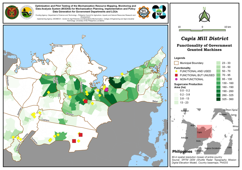
M3DAS App, Database, and Web maps are among the products generated by the project.
The map shows the functionality of government-generated machines. Other maps, include, among others: 1) production areas and varieties planted in the Capiz Mill District, which can aid in the determination of possible yields and performance of the variety for the area’s agro-ecological condition; 2) Map showing machine ownership in the Iloilo Mill District– a more complete picture of mechanization in the area, which would provide SRA information on which areas still need machines especially for custom-hired units, where most of the provision come from government; 3) Map in the Cais Mill District showing production areas and present condition of machines and implements including age of machine— the age and condition of the machine could be causative factors for reduced efficiency and increased operational costs.

