In this Article

This two year research project conducted in Saug Watershed in Davao del Norte and Compostela Valley Province yielded several significant science-based data and results, as well as instrumentation knowledge, which are very useful for planners, policy makers, researchers, students and other stakeholders who have interests and involvement in the proper management of the watershed to sustain their economic livelihood and environmental well-being.
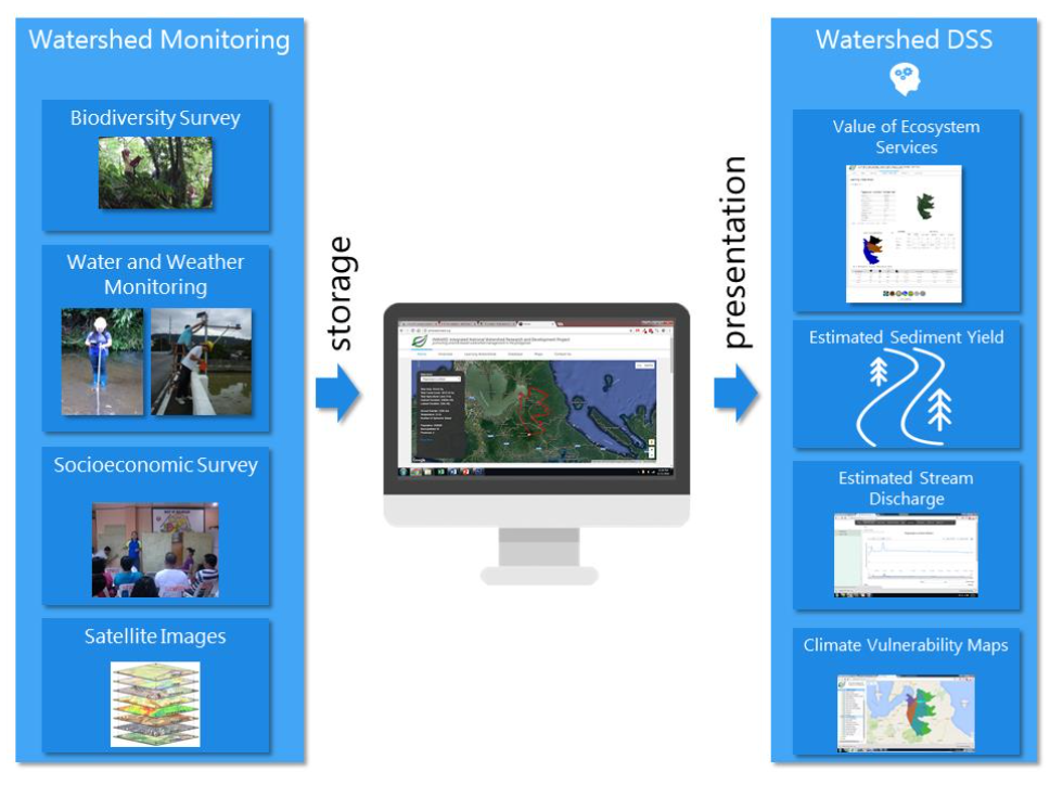
- Founded on the vision of enhancing science and technology-based watershed and ecosystem management, the general objective of this project is to develop a network of learning watersheds and watershed management decision support system. Specifically, this project aims to:
- establish wireless sensor networks that will provide real-time information on water quantity and quality, local climate and soil conditions of selected watersheds;
- establish networks of permanent biodiversity monitoring plots;
- assess the interrelations of watershed and ecosystem services with human and natural factors;
- develop and/or validate models and tools on hydrology, biodiversity and land allocation;
- develop a data-integration and information-management system that synthesizes data from the watershed networks into real-time spatial estimates of water balance, sediment yield, flood and landslide risks;
- conduct selected studies in the watersheds as discussed above;
- develop culture of research among graduate and undergraduate students in watershed management and allied fields;
- build up capacity of local government units, schools and other local stakeholders for watershed monitoring and for the use of watershed databases in planning and decision making; and
- generate data and information that will feed into the SARAI project and other related projects, and that will be useful in local and national policy development.
Based on the results, Saug watershed classified as a big watershed with a total land area of 99,871 hectares is already degraded and critically endangered if not properly managed and rehabilitated. Findings on the water quantity of the two major river tributaries based on installed instrumentation using the water level monitoring station (WLMS) showed low water supply for extended periods ranging from 6-12 months with a mean value of 2.81m during the 22–month observation period from April 2014 to March 2016. The low water supply in the rivers resulted to less supply of irrigation water being experienced by lowland rice farmers. High water levels occurred continuously for four months (December 2016 to March 2016) in downstream Pagsabangan River reaching from 8.0- 10.0 meters while in midstream New Bohol River, high water levels also occurred continuously for five months (December 2015-April 2016) ranging approximately from 4.75-7.0 meters high. During the 12–months monitoring (April 2015 to March 2016), the water level in Pagsabangan River had a low mean level of 3.49 meters and 2.31 meters respectively.
To address the degradation of the Saug watershed it is recommended that massive reforestation and tree growing should be done especially in areas vulnerable to flooding and landslides not only by government agencies but by non-government organizations, private groups, banana plantation owners and other stakeholders of the watershed. More researches should be conducted where results can be used as input to policy makers, planners and managers for sustainable conservation and management of Saug watershed.


