In this Article
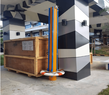
Project FRIES or the Freshwater Morphology Information-Encoding System, is a technology developed by a team of Science teachers and students of the Philippine Science High School, Eastern Visayas Campus through the PCAARRD-GIA funded project titled “Project 3. River flow computational modelling of the Binahaan River System in Leyte” under the “Biodiversity and Vulnerable Ecosystems Research (BiVER) Program”. The BiVER Program was headed by Dr. Janeth Morata-Fuentes as program leader and Engr. Vinci Gabumpa as the project leader for Project 3.
The device was developed primarily to record the morphological characteristics of the Binahaan River System, determine the water level and river flow, survey the river’s width; and create a computational model relating the riparian vegetation diversity to the river’s morphological characteristics. The device is composed of two main components namely: the water flow and level encoder (WaFLE) unit and the automated river morphology survey (ARMS) unit. Each unit was field tested and evaluated in one section of the Binahaan River. The device was initially developed through the fabrication of the circuit and the programming of the code. The device is portable and it can record information like water flow and water level. It also has the ability to store sets of data to an off-site receiver. It has a modular frame which is waterproof and has the ability to send data to a centralized controller using the LoRa Module. It integrates an accelerometer that orients the device with respect to the river. It has an SD card module that creates a record of gathered data. It has a WiFi module that sends data to GoogleSheets. Patent Application for the technology has already been filed and is waiting for approval.
Project FRIES helped in the development of geospatial map models relating river morphology and biological diversity. The developed geospatial maps helped the proponents determine which portions of the river need to be prioritized for management and conservation. Results showed that portions of the river near residential areas and the area that is most accessible to sand mining were found to be very highly sensitive to disturbance and fairly capable of recovery. Particularly, river parameters showed moderate to strong correlation with diversity indices, with width-to-depth ratio showing the highest correlation, denoting greater bank instability and lower biodiversity as it increases in value. Ultimately, results showed that the use of models to understand relationships among river characteristics, biodiversity and anthropogenic effects can be attained to create a holistic profile of a river system.

